
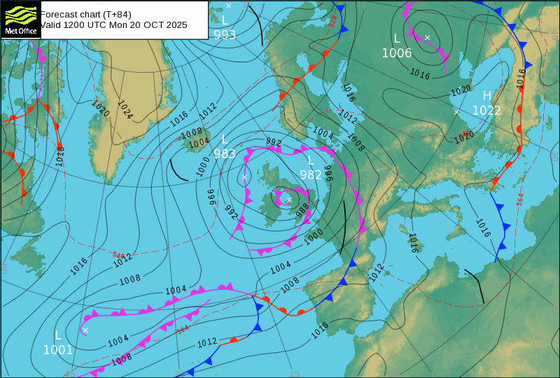
After much anticipation, rain has finally arrived in Portugal - bringing an unstable regime with high humidity as the anticyclone retreats, allowing depressions to move southward, transporting subtropical air toward mainland Portugal. Weather forecasts for Monday and Tuesday confirm this pattern!
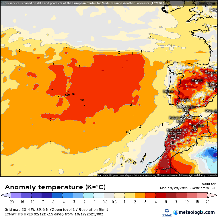
Despite the retreat of high pressure, it still maintains some influence, so we continue to predict temperatures remaining above average, particularly in the South, with values approaching 30°C south of the Tagus River. In these regions, rainfall is minimal, replaced by muggy and uncomfortable conditions.
In the North, temperatures drop but remain mild, with minimum temperatures staying above average - typical of these subtropical flows. While rain is expected, the amount of precipitation remains uncertain, as these episodes are always surprising and difficult to model.
We have an "atmospheric river" connecting the subtropical Atlantic to mainland Portugal with significant moisture, but countered by high geopotential that limits precipitation or pushes it northward.
In the islands, humid conditions continue, with the Azores experiencing disturbance effects, rough seas, and strong winds!
The deepening of this depression remains uncertain - a key factor that will define precipitation levels in mainland Portugal and Madeira - but fortunately, no severe weather situations are expected for now!
In Madeira, rainfall is possible, particularly on Monday, but limited to occasional showers with persistent light precipitation expected in mountainous areas and potential fog.
Temperatures continue above average in the archipelagos and in Central and Southern mainland Portugal.
Weather on Monday, October 20, 2025
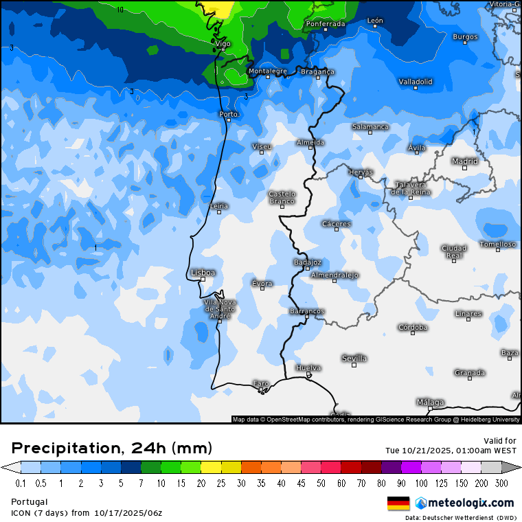
Mainland Portugal expects cloudy skies with breaks, some precipitation moving from North to South during early morning, followed by gradually drier conditions with good breaks between approximately 9am and 6pm. More precipitation is expected from late afternoon, especially in the North, potentially intense in Minho and Douro Litoral by day's end.
Winds from West or Southwest, generally weak to moderate (15-25 km/h), with moderate conditions (30 km/h) and gusts up to 45 km/h in highlands.
Temperatures range from 14-18°C (minimums) - warmer nights than usual - and 19-24°C maximums in the North, 24-28°C in Center and South.
Sea conditions remain relatively calm with waves up to 2 meters on the Western Coast north of Cabo Carvoeiro, water temperature 17-19°C. Southern Algarve coast waves below 1 meter, water around 21°C.
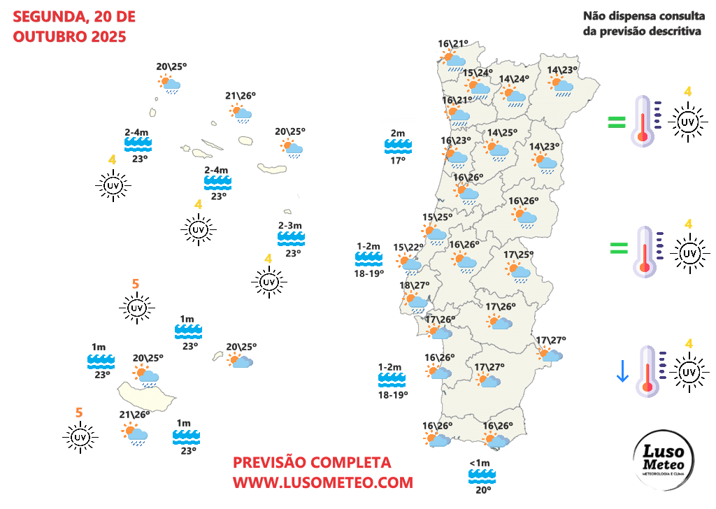
In the AZORES, expect very cloudy periods with breaks, especially during afternoon. Light showers or periods of weak rain expected, particularly in mountainous areas, with moderate Southwest winds (20-35 km/h), stronger gusts in Western Islands (up to 50 km/h).
Temperatures remain above average with tropical minimums (>20°C) and maximums above 24-26°C. Sea becomes rough with waves between 2-4 meters in the afternoon, particularly in Western and Central Island groups, water temperature around 23°C.
In MADEIRA, generally very cloudy skies with breaks in Porto Santo. Periods of weak rain or light showers expected, especially in Madeira Island and mountainous points. Fog possible.
Temperatures above average, similar to previous days, with weak to moderate West winds (10-25 km/h). Calm sea with waves up to 1 meter, water at 23°C.
Weather on Tuesday, October 21, 2025
With shift to NAO- regime and nearby depressions, mainland Portugal expects another cloudy day with breaks in southern regions. Rain will fall, more persistent north of Montejunto-Estrela mountain system, sometimes moderate.
Southern regions may experience minimal rainfall (drizzle), less likely in Algarve where sunshine may continue in some areas.
Winds from West, moderate to strong (30-40 km/h), with gusts up to 55 km/h in highlands until late morning.
Temperatures range from 14-18°C (minimums) - another warmer night than usual - and 19-22°C maximums in the North, 24-28°C in Center and South - maintaining warm, muggy conditions despite rainfall.
Sea relatively calm with waves up to 2 meters on Western Coast north of Cabo Carvoeiro, water temperature 17-19°C. Southern Algarve coast waves below 1 meter, water around 21°C.
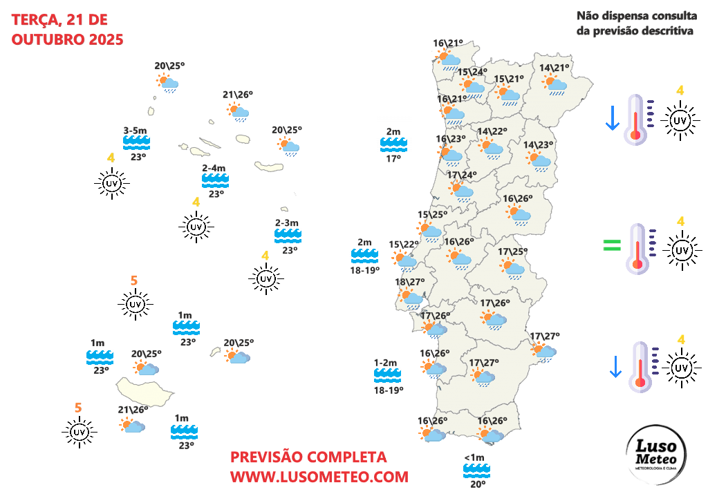
In the AZORES, expect cloudy periods with breaks, especially during morning. Weather may worsen during afternoon - rain, occasional in morning, may become more persistent in afternoon.
Winds initially moderate (20-35 km/h) from Southwest, potentially intensifying with gusts up to 60 km/h across all islands, occasionally 70-80 km/h.
Temperatures remain unchanged, maintaining muggy conditions. Rough seas with waves up to 5 meters in Western Islands, 3-4 meters elsewhere, sea water around 23°C.
In MADEIRA, expect cloudy periods with more breaks. No significant rainfall expected, though occasional light showers cannot be ruled out.
Weak to moderate West winds (10-20 km/h), temperatures without relevant changes, calm sea with water around 23°C.
This will be the start of the week, with some precipitation expected to intensify in the second half - though forecasts remain highly uncertain, stay alert!


Comments
Join Our Community
Sign up to share your thoughts, engage with others, and become part of our growing community.
No comments yet
Be the first to share your thoughts and start the conversation!